


6.0-magnitude earthquake, two aftershocks hit West Sumba

An earthquake measuring 6.0 on the Richter Scale hit West Sumba on Sumba Island, NTT Province, on Tuesday(22/1) at 7:59 a.m. local time, but the tremor did not have potential to trigger a subsequent tsunami.
Kupang (ANTARA News NTT) - An earthquake measuring 6.0 on the Richter Scale hit West Sumba on Sumba Island, East Nusa Tenggara (NTT) Province, on Tuesday (22/1) at 7:59 a.m. local time, but the tremor did not have potential to trigger a subsequent tsunami.
The quake`s epicenter was located at 10.52 degree southern latitude and 119.05 eastern longitude, some 92 km southwest of Waikabubak town, West Sumba District, and at a depth of 47 km, according to Rahmat Triyono, head of the earthquake and tsunami department of the Meteorology, Climatology and Geophysics Agency (BMKG).
Following the earthquake, West Sumba was jolted by two aftershocks respectively measuring 5.2 and 3.2 on the Richter Scale, Rahmat Triyono said.
The tremors were felt by local residents of Tambolaka at IV-V MMI (modified mercalli intensity), Waingapu, Sumbawa and Bima at III MMI. Reports of damages caused by the quake and aftershocks were not available immediately.
Based on the data of the quake`s epicenter and hypocenter depth, the earthquake was a shallow one, and caused by subduction activities of Indo-Australia flank to Eurasia.
Indonesia is one of the most disaster-prone countries in the world, as it is located on the "Pacific Ring of Fire," where a large number of volcanoes and earthquakes occur.
Baca juga: 5.2-magnitude earthquake hits Rote Island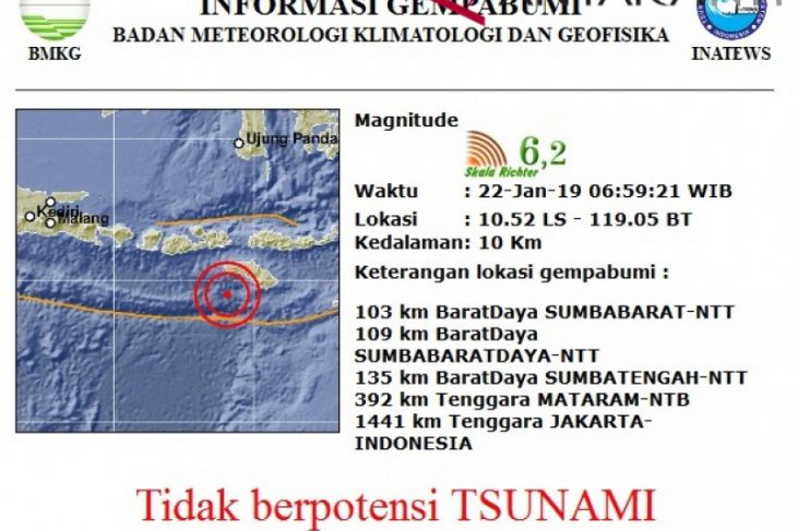
Pewarta : Bernadus Tokan
Editor:
Laurensius Molan
COPYRIGHT © ANTARA 2026


